Archived Lightning data is available in the Energy
and Wind Energy editions of MxVision
WeatherSentry Online
|
|
This layer contains all of the cloud-to-ground strokes which occurred within your selected time frame and purchased region. Here, you are able to set a time period of up to 24 hours within the last 72 hours. If desired you may select an amplitude threshold and polarity.
To set your preferences, hover over the preferences arrow in the Layer Settings.
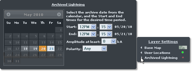
This layer contains all of the cloud-to-ground strokes which occurred within your selected time frame and purchased region. Select the calendar date and then the start and end time, up to 24 hours. If desired you may select an amplitude threshold and polarity.
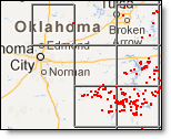
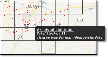
The Archived Lightning layer is available at all zoom levels. The data is represented as points contained in grid boxes or cells. Hover your mouse over one of the cells to view a summary of the lightning data within that cell.
Click over the cell to get details about all lightning strokes within it. The lightning stroke details can be saved to a comma delimited format (csv) file which can be opened in an application such as Microsoft® Excel.
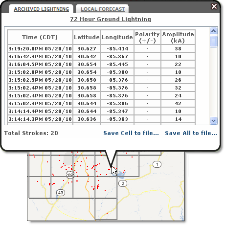
Select the Save Cell link to save only the data within one cell. Use the Save All link to save all archived data within the area currently viewed on your screen and your selected time frame.
The archived lightning data is displayed as points contained in cells drawn over your map. The area of a cell varies from one zoom level to another and by latitude due to the map projection. The Distance Tool can give you a rough idea of the area covered at various zoom levels and latitudes.
![]()
![]()