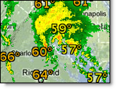
Historical storm corridors depict the event impact which was forecast to occur during the 10 minute period immediately following the valid time of the corridor. Historical storm corridors can be viewed by clicking the Storm Corridors layer within the Storm History layer menu.
|
|
Historical storm corridors are available for the past hour - out to the past seven days. To view preferences hover over the small arrow next to historical storm corridors in the Layer Settings menu.
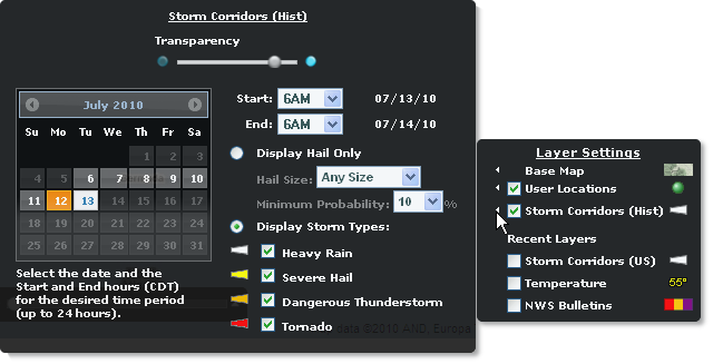
Set your preferences filter to display any or all storm types or only those with a minimum probability and size of hail. A sliding 24 hour window can be viewed at one time. The date colored in gold represents the start date of your 24 hour window. The corridors are color-coded based on the type of activity which was detected in the storm cell by NEXRAD at the valid time.
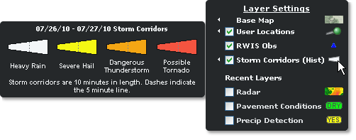
To view the historical storm corridor legend, hover over the storm corridor symbol in the Layer Settings menu.
|
Heavy Rain |
Intense precipitation, strong wind and/or small hail has been detected. |
|
Severe Hail |
An event having at least a 25% probability of severe hail with a diameter of 1" (2.5 cm) or greater has been detected. Note: The NWS has recently changed the definition of Severe Hail from .75" to 1". |
|
Dangerous T-Storm |
A strong thunderstorm with a mesocyclone (rotation aloft) having an index of 1 or greater has been detected. |
|
Possible Tornado |
A thunderstorm with a tornadic vortex signature (TVS) has been detected. |
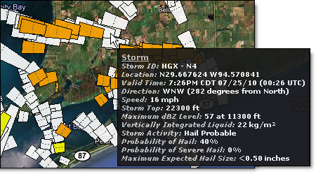
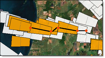
A storm can be tracked by using the historical storm corridor data.
This example shows the location of storm HGX - N4. The popup displays the forecast data provided at 7:26PM.
The last position of the storm is shown in this example. The popup displays the forecast data provided at 7:50PM.
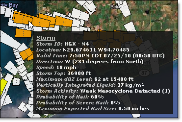
Using this method you are able to determine the final storm path of HGX - N4.
|
Detected Activity |
Definition |
|
The probability of hail and/or severe hail and the maximum size expected. Severe hail is defined as hail with a diameter of 1" (2.5 cm) or greater. | |
|
Rotation detected at multiple levels in a storm and the stringent wind and wind shear criteria are met. Strength is categorized using an index of 1 - 6+. | |
|
Tornadic Vortex Signature (TVS) |
Indication of a possible tornado. Strong wind shear has been detected in a very small area and is usually associated with a potential tornadic circulation within a thunderstorm. |
The following radar reported index value representing the strength of a mesocyclone signature is used within storm corridors.
|
Value |
Descriptor |
Definition |
|
0 |
None |
No mesocyclone |
|
1 - 2 |
Weak |
Weak mesocyclone detected |
|
3 - 5 |
MDT |
Moderate mesocyclone detected |
|
6+ |
Strong |
Strong mesocyclone detected |
|
255 |
Error Condition |
Error condition |
|
Full Length |
10 minute forecast period |
|
Half Length |
5 minutes (depicted as dashed line) |
![]()
![]()


