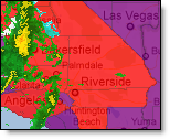
Current National Weather Service Tornado warnings will flash red in counties and marine zones affected.
|
|
The National Weather service (NWS) bulletins can be viewed by clicking the NWS Bulletins layer within the Weather Layers. A flashing county means that a tornado warning has been issued for that county.
To view preferences hover over the small arrow next to NWS bulletins in the Layer Settings menu.
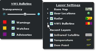
Select any or all of the bulletin types to be displayed on the map. The transparency can also be determined here. Note: If any of the three available bulletin layers are turned on, all tornado and severe thunderstorm warnings will be displayed.
A summary of alerts in effect for a county can be viewed by hovering over the county of interest.

The summary will list all issued bulletins for the county whether or not that bulletin layer is turned on. Each alert currently in effect is listed and color coded by type of alert; warning, watch or advisory.
|
Purple |
NWS advisory has been issued. |
|
Gold |
NWS watch has been issued. |
|
Red |
NWS warning has been issued. |
The full text of the alert(s) in effect for a county can be viewed by clicking the county of interest while the bulletin layers is turned on. Here you can see the reasoning for the alert. The full text will be listed in order of severity with the most severe alert at the top.
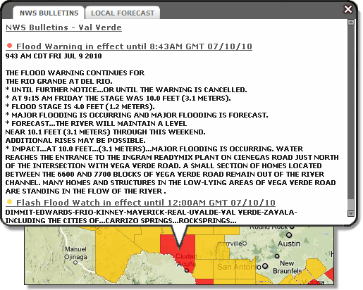
Note: Currently the full text can be printed from the layered map only by right clicking over the text and choosing Select All then Print. A more efficient method is to print the alerts by selecting NWS Weather Reports or National Graphics to access the text alerts from the NWS.
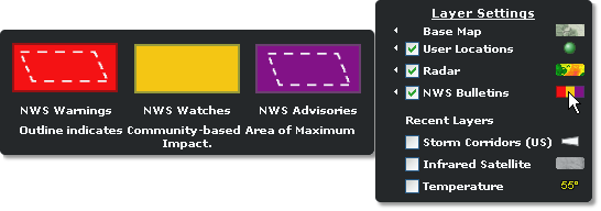
To view the NWS Bulletins legend, hover over the symbol. The legend is dynamic and will display only those NWS layers you have turned on.
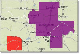
The Area of Maximum Impact is encoded in the warning or advisory issued by the NWS. Schneider Electric decodes this outline and presents it within the layer. You can then see what part of the county is most likely to be affected by the hazardous weather event. Click on the county to view the bulletin text.
Enable any, or all, of the three National Weather Service (NWS) bulletin layers (warnings, watches and/or advisories) to view issued bulletins. Note that this will also include marine zones as defined by the NWS. NWS bulletins are not available for Canadian locations.
|
NWS Warnings |
Definition |
|
Tornado Warning |
Tornado sited by spotters or detected by radar within the county. Tornado Warnings will flash on the Layered Map. |
|
Thunderstorm Warning |
Spotters report or radar detects winds of 58 mph (93 km/h) or greater and/or hail 1 inch (2.5 cm) or greater within the county. Note: The NWS has recently changed the definition of Severe Hail from .75" to 1". |
|
Flood/Flash Flood Warning |
Flash flooding is reported, precipitation estimates indicate flash flooding is likely, or dam/levee failure is imminent or occurring within the county. |
|
NWS Watches |
Definition |
|
Tornado Watch |
Conditions are favorable for tornadoes. |
|
Thunderstorm Watch |
Conditions are favorable for severe thunderstorms. |
|
Flash Flood Watch |
Conditions are favorable for flash flooding. Dam/levee failure is possible but not imminent. |
|
NWS Advisories |
Definition |
|
Blowing Snow Advisory |
Widespread or localized blowing snow reducing visibilities to ¼-mile (400 m) or less and winds are less than 35 mph (56 km/h). |
|
Fog Advisory |
Widespread or localized fog reducing visibilities to ¼-mile (400 m) or less. |
|
Blizzard Advisory |
Blizzard conditions expected. Blizzard conditions are defined as the following for at least three hours: sustained wind or frequent gusts of 35 mph (56 km/h), falling or blowing snow, and visibility frequently ¼-mile (400 m) or less. |
|
Snow Advisory |
Snow accumulation meeting or exceeding locally defined criteria expected within next 24 hours. |
|
Freezing Rain Advisory |
Ice accumulations expected to meet or exceed locally defined criteria. |
|
Winter Weather Advisory |
More than one winter weather hazard meeting or exceeding locally defined criteria is expected. |
|
Wind Chill Advisory |
Wind chill temperatures reaching or exceeding locally defined criteria are expected. |
|
Frost/Freeze Advisory |
Temperatures forecast to reach between 33 and 36°F (.5 and 2°C) for a Frost Advisory and 32°F (0°C) or less for Freeze Advisory. |
|
High Wind Advisory |
Sustained winds of 40 mph (64 km/h) or greater for at least one hour or sustained winds of 58 mph (93 km/h) or greater for any period. Winds are not associated with severe local storms. |
|
Heat Advisory |
Heat index values reach or exceed locally defined criteria for at least two days. |
![]()
![]()