
Storm Corridors are available only over the US.
|
|
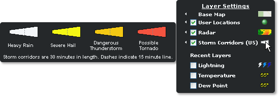
The storm corridors can be viewed by clicking the Storm Corridors layer within the Weather Layers. Storm corridors depict the area which the storm cell is expected to impact over the next half hour. The corridors are color-coded based on the type of activity detected in the storm cell by NEXRAD. A flashing corridor means a TVS has been detected.
To view preferences hover over the small arrow next to storm corridors in the Layer Settings menu.
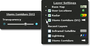
Select the preferences arrow to change the transparency of the storm corridors.
To view the storm corridor legend, hover over the storm corridor symbol in the Layer Settings menu.
|
Heavy Rain |
Intense precipitation, strong wind and/or small hail has been detected. |
|
Severe Hail |
An event having at least a 25% probability of severe hail with a diameter of 1" (2.5 cm) or greater has been detected. Note: The NWS has recently changed the definition of Severe Hail from .75" to 1" in diameter. |
|
Dangerous T-Storm |
A strong thunderstorm with a mesocyclone (rotation aloft) having an index of 1 or greater has been detected. |
|
Possible Tornado |
A thunderstorm with a tornadic vortex signature (TVS) has been detected. Corridors depicting a TVS will flash. |
Corridors are viewed as small squares at the widest zoom levels.
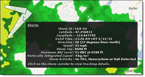
Additional information is available by hovering over the displayed corridor.
Click on the storm corridor to view the storm path tracking details.
![]()
In addition to the storm details, storm path tracking list the locations in the path of the storm, estimated arrival time and the number of minutes until that arrival time.
|
Detected Activity |
Definition |
|
The probability of hail and/or severe hail and the maximum size expected. Severe hail is defined as hail with a diameter of 1" (2.5 cm) or greater. | |
|
Rotation detected at multiple levels in a storm and the stringent wind and wind shear criteria are met. Strength is categorized using an index of 1 - 6+. | |
|
Tornadic Vortex Signature (TVS) |
Indication of a possible tornado. Strong wind shear has been detected in a very small area and is usually associated with a potential tornadic circulation within a thunderstorm. |
The following radar reported index value representing the strength of a mesocyclone signature is used within storm corridors.
|
Value |
Descriptor |
Definition |
|
0 |
None |
No mesocyclone |
|
1 - 2 |
Weak |
Weak mesocyclone detected |
|
3 - 5 |
MDT |
Moderate mesocyclone detected |
|
6+ |
Strong |
Strong mesocyclone detected |
|
255 |
Error Condition |
Error condition |
|
Full Length |
30 minute forecast period |
|
Half Length |
15 minutes (depicted as dashed line) |
![]()
![]()


